| Febrl - Freely extensible biomedical record linkage |
| Febrl - Freely extensible biomedical record linkage |
Using locality information from external sources, distance comparison
can be calculated when postcodes or similar fields are available in
data sets. This field comparator uses a geocode look-up table (where
for each entry longitude and latitude are stored) to calculate the
distance in kilometers between two values. The argument
geocode_table must be set to a reference to a geocode look-up
table as defined and loaded using methods from the
lookup.py module (see Chapter 14 for
more details).
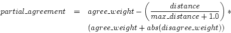
An additional argument is max_distance (a positive number in
kilometers) which gives the maximum distance that is tolerated. If the
calculated distance between two fields is equal to or less than the
value in max_distance, a partial agreement weight is
calculated using the following formula.
If the distance is larger than max_distance, the disagreement
weight is returned.
In its current version no frequency dependent weight calculation is
possible, thus the arguments frequency_table,
freq_table_max_weight and freq_table_min_weight
can not be used with this field comparator function.
| Febrl - Freely extensible biomedical record linkage |